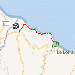
Trail Walking Le Lorrain - La Crabière - Photo
 GabyG
GabyG

User GUIDE

© OpenStreetMap contributors
Length
Length
5.2 km
Max alt
Max alt
66 m
Uphill gradient
Uphill gradient
117 m
Km-Effort
Km-Effort  
6.7 km
Min alt
Min alt
3 m
Downhill gradient
Downhill gradient
108 m
Boucle
Boucle
No
Creation date :
2019-01-15 13:02:54.821
Updated on :
2019-01-15 13:02:54.821

(0 Reviews)

Walking
Walking
1h26
Difficulty : Medium

Scan this QR Code to open this trail in the SityTrail application

FREE GPS app for hiking

Logo SityTrail SityTrail

IGN / Geographical institutes

Download SityTrail from the App Store Download SityTrail from Google Play

Logo SityTrail SityTrail Plus

The world is yours!

Download SityTrail from the App Store Download SityTrail from Google Play Download SityTrail on Huawei AppGallery

About

Trail Walking of 5.2 km to be discovered at Martinique, Unknown, Le Lorrain. This trail is proposed by GabyG.

Description

La Crabière est une randonnée sur les traces des Amérindiens. Belle rando sportive qui demande une connaissance du terrain et des conditions physique particulières. montés et descente par endroits; Vues magnifiques sur l'Atlantique.

Elevation profile

Photos

Points of interest

Point of interest Le Lorrain - Point 1 - Photo
GabyG
LE LORRAIN 
Point of interest Le Lorrain - Point 3 - Photo
GabyG
LE LORRAIN 

Positioning

Country:
France
Region :
Martinique
Department/Province :
Unknown
Municipality :
Le Lorrain
Location:
Unknown
Start:(UTM)
708264 ; 1640809 (20P) N.


Close
My subscriptions